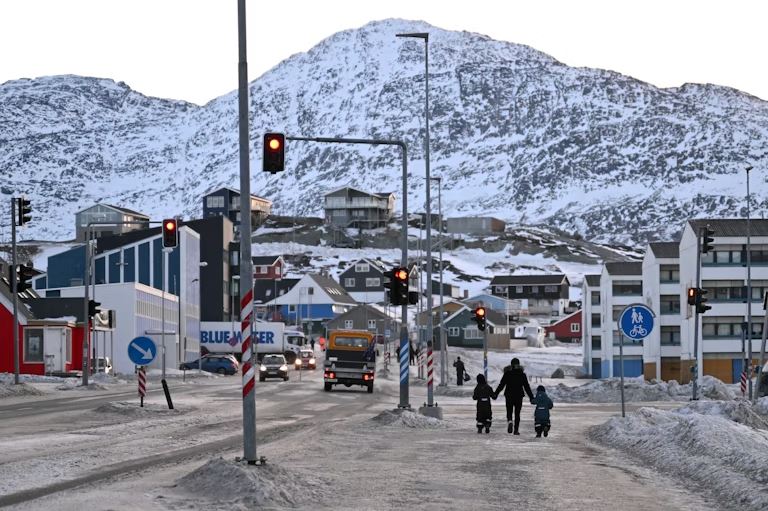
When Donald Trump publicly suggested that the United States should acquire Greenland, the proposal was widely framed as political theatre. Yet when viewed through the lens of oceanography and atmospheric science, Greenland’s strategic logic becomes both measurable and compelling.

Donald Trump in World Economic Forum (Source: Politico, Trump’s Greenland gambit could undermine critical minerals meeting)
This is not primarily about sovereignty or symbolism. It is about waves, wind, ice, and visibility—the physical limits that govern what maritime power can realistically achieve in the high-latitude North Atlantic and Arctic.
A sea state that overwhelms even the largest ships
The waters surrounding Greenland sit at the intersection of Arctic outflow and North Atlantic storm tracks. Long-term buoy records, satellite altimetry, and wave hindcasts consistently show that:
- Mean winter significant wave heights (Hs) reach 4–6 m,
- Storm conditions frequently exceed 8–10 m,
- Extreme events regularly produce Hs >12–15 m, with peak wave periods of 14–18 seconds.
These are not short, steep wind waves but long-period swells generated by intense extratropical cyclones propagating across long fetches (Young et al., 2011; Semedo et al., 2013).
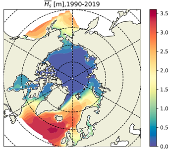
Average significant wave height (𝐻ₛ) for the period 1990–2019, showing the spatial distribution of mean wave energy across the North Atlantic and Arctic Oceans. Elevated 𝐻ₛ values are evident in high-latitude regions influenced by strong winds and reduced sea-ice cover, highlighting the persistently harsh sea states surrounding Greenland that constrain long-term maritime and naval operations (Casas-prat et al., 2023)
For aircraft carriers, the implication is severe. Flight operations depend not only on wave height but on deck motion limits—roll, pitch, and heave accelerations that quickly exceed safe thresholds under long-period swell. Even very large carriers experience persistent no-fly conditions when Hs exceeds roughly 4–5 m, a threshold surpassed for much of the year in the Greenland–Iceland–UK corridor.
In practical terms, the ocean itself sharply reduces the availability of ship-based air power.
Marine icing: a rapid and quantifiable failure mode
Beyond waves, marine icing represents one of the most serious operational hazards in Greenlandic waters—and one of the least appreciated outside polar research.
Field observations and numerical studies indicate that when:
- air temperatures fall below −5 °C,
- wind speeds exceed 20–25 m s⁻¹ (≈40–50 knots), and
- significant wave heights are large enough to generate heavy spray,
- icing rates of 2–4 cm per hour or more are common (Overland et al., 1986; Pease et al., 1998).
Under such conditions, tens of centimetres of ice can accumulate on superstructures, sensors, and exposed decks within hours. The consequences are cumulative and systemic:
- increased top-weight reduces vessel stability,
- radar and communication systems lose accuracy,
- flight decks become unsafe for personnel and aircraft,
- and de-icing operations consume time, fuel, and manpower.
For floating airbases, icing is not an inconvenience—it is an operational stop condition.
Winds that erode persistence, not just performance
The North Atlantic north of 60° N is dominated by frequent gale-force winds, particularly in winter. Reanalysis data show:
- mean seasonal wind speeds of 10–15 m s⁻¹,
- regular storm events exceeding 25–30 m s⁻¹,
- and extremes surpassing 35 m s⁻¹ during rapidly deepening cyclones.
Unlike tropical oceans, where calm windows are relatively predictable, high-latitude storms intensify quickly and linger. Ships must constantly adjust their heading to manage sea state, which increases fuel consumption and reduces endurance. The result is not just degraded performance, but reduced persistence—the ability to remain on station over time.
Seeing without seeing: chronic visibility limits
Even when waves and wind briefly permit operations, visibility often does not. The Greenland and northern North Atlantic region is characterised by:
- persistent fog driven by cold–warm air mass interactions,
- low cloud ceilings,
- snow, sleet, and blowing sea spray.
Meteorological observations show that visibility below 1 km is common for extended periods, particularly during winter and transitional seasons (Tjernström et al., 2019). Optical systems degrade, infrared sensors lose contrast, and radar clutter increases due to precipitation and spray. Situational awareness becomes fragmented—especially on mobile platforms that depend on uninterrupted sensor fusion.
The climate modes behind the hostility: NAO and AO
Crucially, these hazards are not random. They are organised by two dominant modes of atmospheric variability: the North Atlantic Oscillation (NAO) and the Arctic Oscillation (AO).
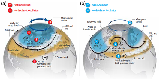
Schematic representation of positive and negative phases of the North Atlantic Oscillation (NAO) and Arctic Oscillation (AO) and their influence on the Greenland–North Atlantic region. Positive NAO/AO phases intensify westerly and circumpolar winds, shift storm tracks poleward, increase fetch length, elevate significant wave heights (>10–15 m), and enhance marine icing risk, collectively reducing ship-based operability while favouring fixed land-based systems in Greenland (Neu et al., 2013)
During positive NAO phases, the pressure gradient between the Icelandic Low and the Azores High intensifies. Stronger westerlies drive more frequent and persistent storms toward northern latitudes, producing higher significant wave heights, longer storm durations, and enhanced air–sea fluxes across the Greenland and Norwegian Seas (Hurrell, 1995; Woolf et al., 2002).
A positive AO phase reflects a strengthened polar vortex and lower surface pressure over the Arctic. This configuration reinforces strong circumpolar winds, favouring gale-force conditions, severe wind chill, and elevated marine icing risk across Arctic and sub-Arctic waters (Thompson & Wallace, 2000).
When NAO and AO are simultaneously positive—a configuration common in winter—the North Atlantic storm track shifts poleward and intensifies. Fetch lengths increase, waves grow beyond 10–15 m, and spray generation accelerates icing. Negative phases may temporarily reduce storminess, but such windows are intermittent and short-lived, reinforcing the region’s overall low predictability for ship-based operations.
Why Greenland succeeds where ships struggle
This is where Greenland’s geography becomes decisive.
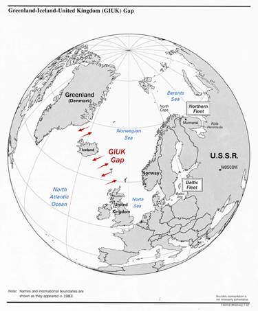
The GIUK Gap (Greenland–Iceland–United Kingdom) forms a critical maritime chokepoint connecting the Arctic Ocean to the North Atlantic. This corridor has long been central to naval surveillance and anti-submarine warfare, as vessels and submarines transiting the Arctic must pass through it. Greenland’s position at the northern anchor of the GIUK Gap underpins its strategic importance for maritime monitoring, early-warning systems, and control of emerging Arctic shipping routes under changing climate conditions.
A fixed, land-based presence is not subject to wave-induced motion, sea-spray icing, or deck operability limits. Radar systems do not pitch and roll. Runways are not coated by freezing spray. Sensors operate continuously, regardless of sea state.
From Greenland, the United States can monitor the GIUK Gap, the critical maritime corridor linking the Arctic Ocean to the North Atlantic. Control of this choke point underpins:
- submarine detection and tracking,
- protection of transatlantic supply lines,
- and NATO’s strategic depth.
This logic is already embedded in reality through Pituffik Space Base, whose location reflects not geopolitics alone, but the physics of polar trajectories, radar performance, and environmental stability.
Climate change raises, not lowers, the stakes
As Arctic sea ice retreats, access increases—but so does exposure. A longer ice-free fetch allows storms to generate larger waves and stronger surges, while enhanced air–sea exchange intensifies wind and spray hazards. Projections suggest increasing extreme wave heights in parts of the North Atlantic–Arctic transition zone through the 21st century (Dobrynin et al., 2012).
The future Arctic is not a calmer ocean. It is a more energetic one.
The strategic lesson written in numbers
Greenland’s importance is not ideological. It is numerical.
- Waves routinely exceed carrier operability limits.
- Icing can disable ships within hours.
- Winds undermine endurance.
- Visibility erodes awareness.
- NAO and AO lock these conditions in place for weeks to months.
In such an environment, sea-based dominance alone is physically constrained. Greenland offers something the ocean cannot: stability above instability. The United States does not need Greenland because it wants more land.
It needs Greenland because the North Atlantic and Arctic refuse to be ruled by ships alone.
References
- · Casas-Prat, M., Wang, X. L., & Swail, V. R. (2023). Projected changes in Arctic and North Atlantic wave climate under diminishing sea ice conditions. Renewable Energy, 206, 1332–1346. https://doi.org/10.1016/j.renene.2023.01.093
- · Dobrynin, M., Murawski, J., & Yang, S. (2012). Evolution of North Atlantic wave climate. Journal of Geophysical Research: Oceans, 117(C00J08). https://doi.org/10.1029/2011JC007799
- · Hurrell, J. W. (1995). Decadal trends in the North Atlantic Oscillation: Regional temperatures and precipitation. Journal of Climate, 8(9), 2283–2303. https://doi.org/10.1175/1520-0442(1995)008<2283:DTITNA>2.0.CO;2
- · Neu, U., Akperov, M. G., Bellenbaum, N., Benestad, R., Blender, R., Caballero, R., et al. (2013). The numerous approaches to tracking extratropical cyclones and the challenges they present. Bulletin of the American Meteorological Society, 94(2), 159–181. https://doi.org/10.1175/BAMS-D-11-00154.1
- · Overland, J. E., Pease, C. H., & Preisendorfer, R. (1986). Prediction of vessel icing. Journal of Climate and Applied Meteorology, 25(2), 179–191. https://doi.org/10.1175/1520-0450(1986)025<0179:POVI>2.0.CO;2
- · Pease, C. H., Overland, J. E., & Preisendorfer, R. (1998). Marine icing climatology of northern seas. Cold Regions Science and Technology, 27(2), 119–135. https://doi.org/10.1016/S0165-232X(98)00006-9
- · Semedo, A., Sušelj, K., Rutgersson, A., & Sterl, A. (2013). A global view on the wind sea and swell climate and variability from ERA-40. Journal of Climate, 26(9), 106–123. https://doi.org/10.1175/JCLI-D-12-00011.1
- · Thompson, D. W. J., & Wallace, J. M. (2000). Annular modes in the extratropical circulation. Part I: Month-to-month variability. Journal of Climate, 13(5), 1000–1016. https://doi.org/10.1175/1520-0442(2000)013<1000:AMITEC>2.0.CO;2
- · Tjernström, M., Shupe, M. D., Brooks, I. M., Persson, P. O. G., Prytherch, J., Salisbury, D. J., et al. (2019). Meteorological conditions in the Arctic during the Arctic Ocean 2018 expedition. Bulletin of the American Meteorological Society, 100(7), 1275–1292. https://doi.org/10.1175/BAMS-D-18-0257.1
- · Wikipedia contributors. (2025). GIUK gap [Map]. Wikimedia Commons. https://en.wikipedia.org/wiki/GIUK_gap#/media/File:GIUK_gap.png
- · Woolf, D. K., Challenor, P. G., & Cotton, P. D. (2002). The variability and predictability of North Atlantic wave climate. Journal of Climate, 15(17), 2485–2498. https://doi.org/10.1175/1520-0442(2002)015<2485:TVAPON>2.0.CO;2
- · Young, I. R., Zieger, S., & Babanin, A. V. (2011). Global trends in wind speed and wave height. Science, 332(6028), 451–455. https://doi.org/10.1126/science.1197219