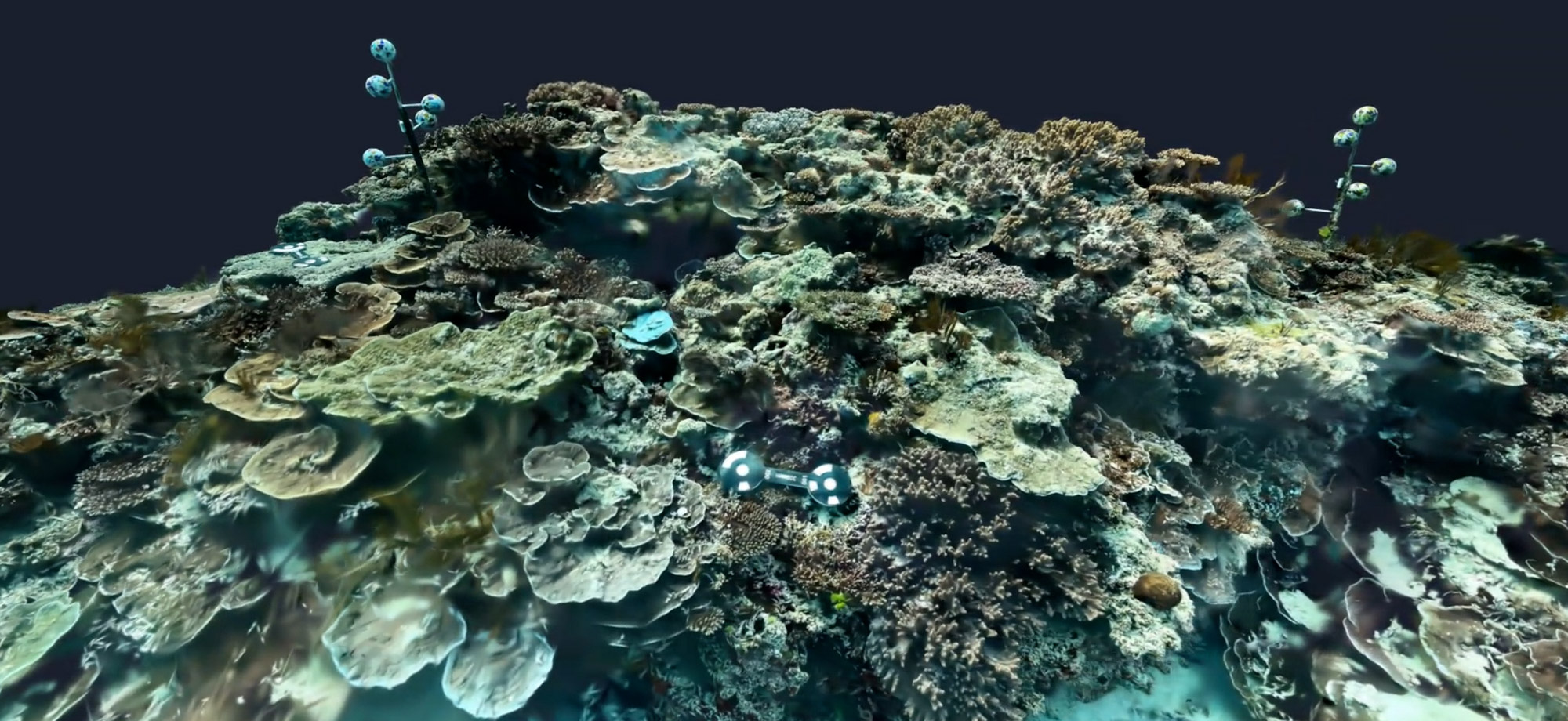
Coral reefs are shrinking faster than we can measure them, and that gap between damage and detection may be the biggest threat we are not talking about. Fourteen percent of the world's coral cover disappeared in a single decade, and up to 90 percent of what remains could be gone by mid-century if warming continues on its current path. Reef scientists have spent decades trying to measure reef structure well enough to catch decline early, but the tools available to most research teams have never matched the scale of the problem.
That balance is now shifting, and the shift is being driven less by new sensors than by what artificial intelligence can do with the data those sensors already collect.
A tape measure was never going to work at reef scale
For most of the twentieth century, reef surveys meant a diver, a tape measure, and a chain draped over the coral to trace its contours, a method that is accurate at the scale of a single colony but useless across a bay. Line-intercept transects and quadrat photographs improved on this, but a diver can only cover so much reef on a single tank of air, and every square metre mapped by hand is a square metre that took real time to record.
When photographs learn to build a reef in 3D
Structure-from-Motion photogrammetry changed the arithmetic. A diver or drone swims or flies a grid over the reef, and software stitches the overlapping photographs into a three-dimensional point cloud, mesh, or orthomosaic accurate to millimetres. Divers using this technique can reconstruct detailed 3D coral models and calculate rugosity, height, and surface roughness at a resolution earlier methods could never reach, and the same computer-vision pipeline can generate digital surface models and stitched-image maps that hold up to real ecological analysis, not just a visual approximation of the reef.
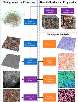
Figure 1. The full photogrammetry-to-analysis pipeline: underwater images and control points feed sparse and dense 3D reconstruction, which in turn produces roughness, height-change, ruggedness and semantic-segmentation products. Source: Zhong et al. (2023), Sensors, CC BY 4.0.
Sound and light take over where cameras fail
Sound and light-based sensors fill a different gap. Sonar, mounted on boats or autonomous vehicles, sweeps wide areas of seabed quickly but cannot resolve fine coral texture or capture colour, which limits its use in shallow, structurally complex reef habitat. Bathymetric LiDAR, which fires green laser pulses from an aircraft that penetrate clear shallow water, offers a non-contact way to survey seabed elevation across whole reef systems without a boat ever touching the coral. NOAA has used this approach around damaged reefs in the Northern Mariana Islands, but the equipment remains costly to fly and the returned signal still needs colour imagery layered on top to tell live coral from bare rock.
Now the model does the mapping
The newest layer is deep learning applied directly to reconstruction and classification. Neural networks can now take a single ordinary underwater or drone video, without special equipment or pre-processing, and turn it into a labelled 3D model in close to real time. In one demonstration, a diver's 100-metre GoPro swim was converted into a semantic 3D point cloud within about five minutes of processing on a single consumer graphics card, a speed roughly two orders of magnitude faster than conventional photogrammetry software attempting the same footage, correctly labelling around 84 percent of the seafloor by benthic class.
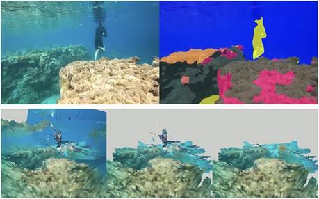
Figure 2. A GoPro video frame (top left) is automatically segmented into benthic classes (top right) and reconstructed into a colourised 3D point cloud (bottom row) within minutes, without any specialised survey equipment. Source: Sauder et al. (2024), Methods in Ecology and Evolution, CC BY-NC 4.0.
Machine-learning classifiers trained on this kind of 3D data can now separate live coral, dead framework, rubble, and sediment with accuracy above 90 percent, and similar networks let a drone flying at twenty metres altitude predict fine-scale complexity metrics that would otherwise require a diver spending days underwater.
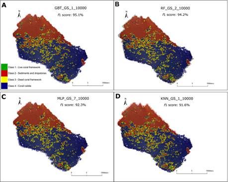
Figure 3. Four machine-learning classifiers applied to the same 3D reconstruction of a cold-water coral mound, each distinguishing live coral, dead coral, rubble and sediment at f1 scores above 90%. Source: de Oliveira et al. (2022), Frontiers in Environmental Science, CC BY 4.0.
Line the numbers up and the trend is unmistakable. Diver-derived photogrammetry, still the accuracy benchmark, tops out around 250 square metres per survey and takes roughly two days of fieldwork and processing to cover a modest 64 square metres, tile by tile. Add a drone and a trained neural network to that same basic technique, and coverage jumps to thousands of square metres per flight: Suan and colleagues mapped 4,636 reef tiles, more than 18,500 square metres, in five hours, work that would have taken an estimated 580 days with divers alone. Sauder's AI-based video reconstruction pushes further still, covering more than a kilometre of transect in a single SCUBA dive. None of these figures are directly comparable, each study surveyed a different reef with a different method, but the direction holds across all of them: coverage per hour of fieldwork keeps climbing while the equipment gets cheaper.
This is a bigger shift than a faster camera
What has actually changed is that reef structure, once something only a specialist diver could quantify square metre by square metre, can now be estimated across whole reef systems by combining cheap imagery with a trained model. A single research dive can generate data that used to demand hundreds of days of diver-hours, and that changes who can realistically run a long-term monitoring programme, not just how fast one dive's data gets processed.
The catches that get glossed over
The gains come with real limits that opinion pieces about the technology tend to skate past. Deep-learning models trained on one reef's colour, light, and species composition do not automatically transfer to a different reef with different water clarity or coral assemblages, so every new site still needs local calibration data from divers. Processing costs and GPU requirements, while falling, are not trivial for research groups in the reef-rich, resource-poor countries where monitoring is needed most. And every camera-based method still depends on visibility: turbid water, which is often exactly where local pollution stress is worst, degrades the very imagery the models need.
None of that argues against the shift, only for realism about it. The direction of travel is toward cheaper sensors doing more of the interpretive work themselves, and toward monitoring programmes that scientists in lower-resourced regions can actually sustain year after year, rather than tools that only well-funded expeditions can afford to run once.
What should change now is not the ambition of these systems but who gets access to them. The reefs most at risk are disproportionately in countries with the fewest research dollars, and a technology built to be cheap and scalable is only as useful as its reach. Making these tools open, transferable across regions, and genuinely low-cost is the work that will decide whether 3D coral mapping becomes a global monitoring standard or stays a demonstration for well-funded labs.
References
de Oliveira, L. M. C., Lim, A., Conti, L. A., & Wheeler, A. J. (2022). High-resolution 3D mapping of cold-water coral reefs using machine learning. Frontiers in Environmental Science, 10, Article 1044706. https://doi.org/10.3389/fenvs.2022.1044706
National Oceanic and Atmospheric Administration. (2024). 2019 NOAA bathymetric lidar with waveform metrics: Saipan, CNMI [Data set description]. NOAA InPort. https://www.fisheries.noaa.gov/inport/item/71943
Sauder, J., Banc-Prandi, G., Meibom, A., & Tuia, D. (2024). Scalable semantic 3D mapping of coral reefs with deep learning. Methods in Ecology and Evolution, 15(5), 916–934. https://doi.org/10.1111/2041-210X.14307
Suan, A., Franceschini, S., Madin, J., & Madin, E. (2025). Quantifying 3D coral reef structural complexity from 2D drone imagery using artificial intelligence. Ecological Informatics, 85, Article 102958. https://doi.org/10.1016/j.ecoinf.2024.102958
Zhong, J., Li, M., Zhang, H., & Qin, J. (2023). Fine-grained 3D modeling and semantic mapping of coral reefs using photogrammetric computer vision and machine learning. Sensors, 23(15), Article 6753. https://doi.org/10.3390/s23156753
Zhong, J., Li, M., Gruen, A., Schindler, K., Liao, X., & Guo, Q. (2025). Cutting-edge 3D reconstruction solutions for underwater coral reef images: A review and comparison. ISPRS Journal of Photogrammetry and Remote Sensing. https://www.sciencedirect.com/science/article/abs/pii/S0924271625003971